
UPDATED - November 21, 2016
 |
| From www.geonet.org.nz - Location of the 7.8 mangitude earthquake in red. |
On Monday, November 14, 2016 at 12:02 a.m. a 7.8 magnitude earthquake struck New Zealand. This severe earthquake did significant damage to homes, roads and other infrastructure and claimed two lives. Since the initial shake there have been thousands of aftershocks (greater than 4,000 since the time of this posting)!
Here is a 24-hr time lapse animation of the aftershock sequence created by NIWA weather:
Mike missed the earthquake as he was travelling around the north island at the time. I was just closing my eyes to go to sleep when I felt the unmistakable feeling of an earthquake. Since I am getting more used to feeling small earthquakes in Christchurch, I decided to let it ride. The motion was like a slow rolling back and forth and the house was making some loud groans and creaks. After about twenty seconds I decided that it was too dangerous to remain still (the longer the shaking lasts the greater the magnitude of the quake). At this point I jumped out of bed and put on my pants and a sweater over my pajamas (just in case I needed to evacuate the house). I then ducked and covered under Mike's office desk. The slow rocking continued for another 60 seconds, which felt extremely long and scary. I was thinking "I hope the epicenter is not in a populated area because this is going to be really bad".
After the shaking stopped I remained under the desk until I felt safe to come out. I returned to bed and quickly checked twitter to see what others were reporting. People were reporting a strong earthquake in Wellington as well as blue flashing lights in the sky. There was also a tsunami warning issued for much of the east coast of the south island and other parts of Christchurch were evacuated. For the next several hours the house grumbled and shook with smaller, yet frequent aftershocks. Needless to say, I did not sleep much that night and was awakened early by texts, calls and Facebook posts from concerned friends and family back home.
After the news came that Kaikoura had taken the brunt of the damaged I was very saddened. Mike and I love to go to Kaikoura and it is one of our favourite places that reminds us of home. I felt worried for the people stranded there and also for the extensive damages to the homes and businesses.
So why did the earthquake last so long? It now seems that an initial 7.8 quake happened 15 km below the surface near Culverdon in the south, which set off a serious of successional quakes that ripped northward with increasing energy for almost 200 km. Several faults were involved resulting in major movements of terrain across the south island. A new coastal fault, known as the Kekerengu Fault, appears to have slipped up to 10 m (see drone footage below)!
This earthquake has likely had a major effect on some coastal populations of animals. Marine biologists estimate that between 50 - 75 % of paua (abalone) and rock lobster may have been lost due to at least a 1 m rise in the sea floor (2 - 2.5 m in some areas). Sadly, a slip wiped out half of a breeding colony of the threatened Hutton's shearwater, resulting in an estimated loss of 25 % of the total New Zealand population. Even more depressing is the waterfall where the baby fur seals like to play in the winter was destroyed (see video of baby seals at the waterfall here).
While the aftershock sequence is seeming to follow the most probabilistic scenario of seismic events gradually reducing in frequency and magnitude overtime, there is still a great risk of another large earthquake in the region in the near future. I will be making sure to have my shoes, water, flashlight, batteries, lighter and some non-perishable food ready to go.
ATTENTION BRITISH COLUMBIANS - A powerful earthquake like this one can happen in BC at any time. PLEASE get your emergency kit together NOW! Make sure you have water, blankets, cash, flashlight, food, first aid kit, etc. Take my experience as YOUR WARNING. Thank you!
~*~*~*~*~*~*~*~*~*~*~*~*~*~*~*~*~~
[original post - April 9, 2015]
Since arriving in Christchurch, New Zealand in November 2015, Mike and I experienced four moderate and one strong earthquakes. So what gives? Well, according to my research the Earth's crust at fault lines, that's what.
Have you heard about the "Ring of Fire"? No, not the Johnny Cash song, I am talking about a 40,000 km path of seismically activity stretching almost around the entire periphery of the Pacific Ocean (Figure 1). According to National Geographic 90 % of all earthquakes occur within the Ring of Fire, which is also home to 75 % of all Earth's active volcanoes.
 |
| Figure 1: Location of the Ring of Fire (http://education.nationalgeographic.org/encyclopedia/ring-fire/) |
Apparently, the microcontinent of New Zealand, which is mostly submerged, is located right on the border of two tectonic plates, known as the Australia-Pacific plate boundary zone. As the two plates grind against each other with incredible force, it is inevitable that a rupture will occur at a weak spot in the crust (known as a fault) resulting an Earthquake. It is the grinding and crushing of plates over time that also causes the formation of mountains and volcanoes. GNS Science has made a nice video to illustrate how New Zealand was formed over time through the activity of these seismic forces:
As you can see in Figure 2 below, there are a number of fault lines (or weak spots) located on both the North and South Islands of New Zealand. On the South Island, where I live, much of the plate movement is reported to occur along the Alpine Fault line; however, oblique plate movement occurs across a 150-200 km wide area in Canterbury known as the Southern Alps. So, even though Christchurch is not directly on top of the Alpine Fault, some of the stress can be transferred through the crust to generate numerous faults in the Canterbury region.
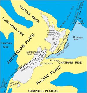 |
| Figure 2: Location of NZ on Australia-Pacific plate boundary zone (GNS Science) |
So, the five earthquakes that we have experienced were actually aftershocks from the 7.1 magnitude Darfield Earthquake of 2010. This earthquake event actually triggered the completely devastating 2011 Christchurch earthquake, which killed 180, injured nearly 7,000, destroyed buildings and displaced so many from their homes. Five years later this resilient community is still rising from the ashes and recovering from the trauma. I will not dedicate too much here on this disastrous event, which has very obviously and deeply effected the community of Christchurch because it is impossible for me describe this as an outsider, who did not experience the event first-hand. I will, however, write a future blog on something that I have experienced in Christchurch: the "Re-build".
The first earthquake that we experienced was on January 28, 2016. This was magnitude 4.1 and considered 'rather strong' with a depth of 8.7 km. I actually didn't feel this one, but my work colleagues did. Mike reported that it first sounded like a truck hit the side of the house and then the ground shook.
The second and strongest earthquake that we experienced was on February 14, 2016. This was a strong earthquake of magnitude 5.8 and depth of 15.4 km. We were enjoying some American style hot dogs at the Riccarton Market when the ground started to vibrate and then after a few seconds the vibration turned into actual shaking as the earth under my bum shifted me back and forth. A couple people at the market screamed out and some folks started running. The quake lasted about 20 seconds and was very unnerving. The Riccarton shopping mall was evacuated and a cliff collapsed in Sumner (see below). Luckily nobody was seriously injured. This strong earthquake did however bring up flashbacks and trauma for many Canterburians who had survived the 2010 and 2011 earthquakes.
Mike and I felt a small aftershock on February 18, 2016 while driving in the car. I noted 'why is the car running so rough?', but it turned out to be an earthquake of magnitude 4.3 and depth of 12.9 km.
Mike awoke at 3:32 am on February 29, 2016 to the shaking from a rather strong 4.2 magnitude earthquake of 5.1 km depth. I however, slept through this earthquake.
The most recent earthquake happened around 11:00 pm on March 12, 2016. This one was rather strong, with a magnitude of 4.4 and depth of 18.6 km.
Update: Another strong earthquake occurred on May 11, 2016 - Magnitude 4.7 and depth of 6.6 km.
The earthquakes that we have experienced since moving to New Zealand are a bit freaky for us, since we have not lived in an area where they occur so frequently, but after five earthquakes we are starting to get used to it. Ultimately, it is the geological forces that have forged the beauty and uniqueness of New Zealand, which we do appreciate.
Home Previous
No comments:
Post a Comment